
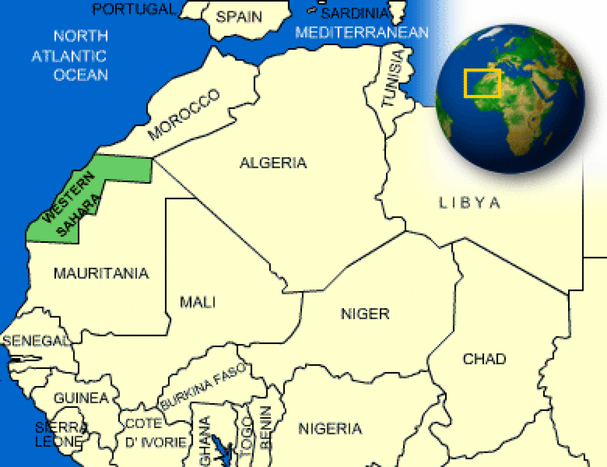
Where is Western Sahara?
What countries border Western Sahara?

Western Sahara Facts
What is the capital of Western Sahara?
| Capital | Laayoune (administrative center) |
| Government Type | legal status of territory and issue of sovereignty unresolved -territory contested by Morocco and Polisario Front (Popular Front for the Liberation of the Saguia el Hamra and Rio de Oro), which in February 1976 formally proclaimed a government-in-exile of the Sahrawi Arab Democratic Republic (SADR), near Tindouf, Algeria, was led by President Mohamed ABDELAZIZ until his death in May 2016; current President Brahim GHALI elected in July 2016; territory partitioned between Morocco and Mauritania in April 1976 when Spain withdrew, with Morocco acquiring northern two-thirds; Mauritania, under pressure from Polisario guerrillas, abandoned all claims to its portion in August 1979; Morocco moved to occupy that sector shortly thereafter and has since asserted administrative control; the Polisario's government-in-exile was seated as an Organization of African Unity (OAU) member in 1984 - Morocco between 1980 and 1987 built a fortified sand berm delineating the roughly 80 percent of Western Sahara west of the barrier that currently is controlled by Morocco; guerrilla activities continued sporadically until a UN-monitored cease-fire was implemented on 6 September 1991 (Security Council Resolution 690) by the United Nations Mission for the Referendum in Western Sahara (MINURSO) |
| Currency | Moroccan Dirham (MAD) |
| Total Area |
102,703 Square Miles 266,000 Square Kilometers |
| Location | Northern Africa, bordering the North Atlantic Ocean, between Mauritania and Morocco |
| Language | Hassaniya Arabic, Moroccan Arabic |
| GDP - per capita (PPP) | $2,500.00 (USD) |
Western Sahara Demographics
What is the population of Western Sahara?
| Ethnic Groups | Arab, Berber |
| Nationality Noun | Sahrawi(s), Sahraoui(s) |
| Population | 652,271 |
| Population - note | note: estimate is based on projections by age, sex, fertility, mortality, and migration; fertility and mortality are based on data from neighboring countries |
| Population Growth Rate | 2.96% |
| Population in Major Urban Areas | Laayoune 237,000 |
| Urban Population | 82.000000 |
Western Sahara Government
What type of government does Western Sahara have?
| Suffrage | none; (residents of Moroccan-controlled Western Sahara participate in Moroccan elections) |
Western Sahara Video
CountryReports YouTube Channel:
Join CountryReports YouTube Channel (Click Here)Western Sahara Geography
What environmental issues does Western Sahara have?
| Climate | hot, dry desert; rain is rare; cold offshore air currents produce fog and heavy dew |
| Border Countries | Algeria 42 km, Mauritania 1,561 km, Morocco 443 km |
| Environment - Current Issues | sparse water and lack of arable land |
| Environment - International Agreements | party to: none of the selected agreements |
| Terrain | mostly low, flat desert with large areas of rocky or sandy surfaces rising to small mountains in south and northeast |
Western Sahara Economy
How big is the Western Sahara economy?
| Economic Overview |
Western Sahara has a small market-based economy whose main industries are fishing, phosphate mining, tourism, and pastoral nomadism. The territory's arid desert climate makes sedentary agriculture difficult, and much of its food is imported. The Moroccan Government administers Western Sahara's economy and is a key source of employment, infrastructure development, and social spending in the territory. Western Sahara's unresolved legal status makes the exploitation of its natural resources a contentious issue between Morocco and the Polisario. Morocco and the EU in December 2013 finalized a four-year agreement allowing European vessels to fish off the coast of Morocco, including disputed waters off the coast of Western Sahara. As of April 2018, Moroccan and EU authorities were negotiating an amendment to renew the agreement. Oil has never been found in Western Sahara in commercially significant quantities, but Morocco and the Polisario have quarreled over rights to authorize and benefit from oil exploration in the territory. Western Sahara's main long-term economic challenge is the development of a more diverse set of industries capable of providing greater employment and income to the territory. However, following King MOHAMMED VI’s November 2015 visit to Western Sahara, the Government of Morocco announced a series of investments aimed at spurring economic activity in the region, while the General Confederation of Moroccan Enterprises announced a $609 million investment initiative in the region in March 2015. |
| Industries | phosphate mining, handicrafts |
| Currency Name and Code | Moroccan Dirham (MAD) |
| Export Partners | Morocco claims and administers Western Sahara, so trade partners are included in overall Moroccan accounts |
| Import Partners | Morocco claims and administers Western Sahara, so trade partners are included in overall Moroccan accounts |
Western Sahara News and Current Events
What current events are happening in Western Sahara?
Source: Google News
World Regions
All Countries
Afghanistan
Akrotiri
Albania
Algeria
American Samoa
Andorra
Angola
Anguilla
Antarctica
Antigua and Barbuda
Argentina
Armenia
Aruba
Australia
Austria
Azerbaijan
Bahamas
Bahrain
Bangladesh
Barbados
Belarus
Belgium
Belize
Benin
Bermuda
Bhutan
Bolivia
Bosnia and Herzegovina
Botswana
Brazil
British Indian Ocean Territory
British Virgin Islands
Brunei
Bulgaria
Burkina Faso
Burma
Burundi
Cabo Verde
Cambodia
Cameroon
Canada
Cayman Islands
Central African Republic
Chad
Chile
China
Christmas Island
Clipperton Island
Cocos (Keeling) Islands
Colombia
Comoros
Congo, Democratic Republic of the
Congo, Republic of the
Cook Islands
Coral Sea Islands
Costa Rica
Cote d’Ivoire
Croatia
Cuba
Curacao
Cyprus
Czech Republic
Denmark
Dhekelia
Djibouti
Dominica
Dominican Republic
Ecuador
Egypt
El Salvador
Equatorial Guinea
Eritrea
Estonia
Eswatini
Ethiopia
Falkland Islands
Faroe Islands
Fiji
Finland
France
French Guiana
French Polynesia
Gabon
Gambia, The
Gaza Strip
Georgia
Germany
Ghana
Gibraltar
Greece
Greenland
Grenada
Guadeloupe
Guam
Guatemala
Guernsey
Guinea
Guinea-Bissau
Guyana
Haiti
Holy See
Honduras
Hong Kong
Hungary
Iceland
India
Indonesia
Iran
Iraq
Ireland
Isle of Man
Israel
Italy
Jamaica
Jan Mayen
Japan
Jersey
Jordan
Kazakhstan
Kenya
Kiribati
Korea, North
Korea, South
Kosovo
Kuwait
Kyrgyzstan
Laos
Latvia
Lebanon
Lesotho
Liberia
Libya
Liechtenstein
Lithuania
Luxembourg
Macau
Madagascar
Malawi
Malaysia
Maldives
Mali
Malta
Marshall Islands
Martinique
Mauritania
Mauritius
Mayotte
Mexico
Micronesia
Moldova
Monaco
Mongolia
Montenegro
Montserrat
Morocco
Mozambique
Namibia
Nauru
Nepal
Netherlands
New Caledonia
New Zealand
Nicaragua
Niger
Nigeria
Niue
Norfolk Island
North Macedonia
Northern Mariana Islands
Norway
Oman
Pakistan
Palau
Panama
Papua New Guinea
Paraguay
Peru
Philippines
Pitcairn Islands
Poland
Portugal
Puerto Rico
Qatar
Reunion
Romania
Russia
Rwanda
Saint Helena, Ascension, and Tristan da Cunha
Saint Kitts and Nevis
Saint Lucia
Saint Pierre and Miquelon
Saint Vincent and the Grenadines
Samoa
San Marino
Sao Tome and Principe
Saudi Arabia
Senegal
Serbia
Seychelles
Sierra Leone
Singapore
Slovakia
Slovenia
Solomon Islands
Somalia
South Africa
Spain
Sri Lanka
Sudan
Sudan, South
Suriname
Svalbard
Sweden
Switzerland
Syria
Taiwan
Tajikistan
Tanzania
Thailand
Timor-Leste
Togo
Tokelau
Tonga
Trinidad and Tobago
Tunisia
Turkey
Turkmenistan
Turks and Caicos Islands
Tuvalu
Uganda
Ukraine
United Arab Emirates
United Kingdom
United States (US)
Uruguay
Uzbekistan
Vanuatu
Venezuela
Vietnam
Virgin Islands
Wake Island
Wallis and Futuna
West Bank
Western Sahara
World
Yemen
Zambia
Zimbabwe