
Venezuela Geography
What is the terrain and geography like in Venezuela?
Overview
Venezuela is located on the northern coast of South America, between 0 degrees 5’ and 12 degrees 15 N, and 59 degrees 45’ and 73 degrees 09 W. It covers 352,150 square miles. The capital, Caracas, is situated in the magnificent Avila Mountains on the north coast at about 2,700 feet above sea level, giving the city a permanent springtime climate.The Orinoco River and various mountain ranges, all branches of the Andes chain, divide the country into a number of distinct regions.
South of the Orinoco, which is the third longest river in South America, is located the wild and largely unexplored Guayana highlands. This area comprises over half of the area of the country and is rich in mineral resources and developed and undeveloped hydroelectric power. In the Gran Sabana area, erosion has caused unusual formations characterized by rugged relief and flat-topped, cliff-edged mountains called "tepuis," the Pemon Indian word for mountain. These sandstone mesas form part of one of the oldest geologic regions in the world, and they have the highest percentage of the endemic flora of any formations on earth. Roraima, one of the most famous of the tepuis, was the setting for "Lost Worlds." Arthur Conan Doyle never actually visited the area, so the reader cannot expect realism in his adventure story, but his characterization of the "tepuis" reflects widely-held beliefs, and the "tepuis" continue to be endlessly fascinating.
Another section of the Guayana highlands is the mysterious and remote Amazonas region, home to various indigenous groups such as the Yekuana, Yanomami, and Piaroa. Although carrying the name of the great river to the south, most of this area lies in the Orinoco drainage basin. The remaining portion of the Orinoco waters go to the Amazon, marking one of the great anomalies of nature—a river called the Casiquiare that crosses the watershed between the Orinoco and Rio Negro (which connects to the Amazon) and joins two of the great rivers of the world. It is possible to travel by water from the Orinoco through the Casiquiare and Rio Negro and to the Amazon. Legends of this route were the basis for many famous explorations by Europeans in the 18th and 19th centuries.
North of the Orinoco is a great expanse of lowlands that occupies approximately one-third of the national territory, known as the "llanos" or plains. During the dry season, the entire area is almost desert-like. But during the rainy season, flooding rivers make the area a maze of water. Alexander von Humboldt, visiting the area in the early 1800s, referred to it as an ocean covered with seaweed. This area contains "hatos" or working ranches, some of which have turned to ecotourism. Visitors can enjoy wildlife viewing from boats or vehicles, sighting capybaras, ocelots, monkeys, tapirs, caimans, and exotic and extensive bird life—more than 350 species have been recorded in the region, including scarlet ibis, or corocoros, with their spectacular plumage. Visitors can also fish for piranha which, despite the dictionary definition, do not usually attack humans.
Spurs of the Andes Mountains run along each side of the Maracaibo basin and part of the seacoast. The bulk of Venezuela’s population traditionally has lived in these northern highlands, attracted by the temperate weather and fertile soil. The city of Mérida is very near Pico Bolivar, Venezuela’s highest mountain and a popular spot for climbing. The longest cable car (teleférico) in the world runs from Merida to Pico Espejo high in the clouds above. It can be warm and sunny in Merida and snowing on Pico Espejo, some 3,100 meters (10,170 feet) higher.
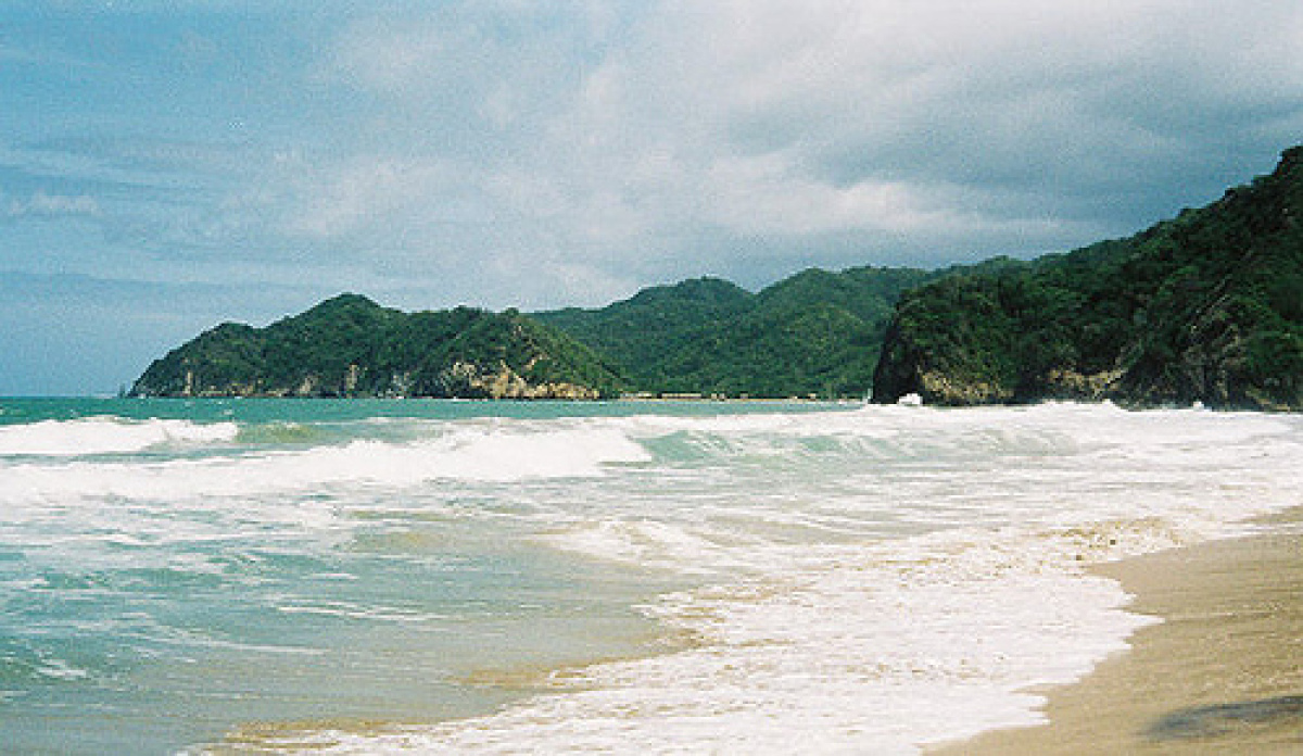
A tropical coastal plain stretches along most of Venezuela’s 1,750-mile coastline. This narrow strip of land between mountains and sea widens in the west to form the Maracaibo basin. The climate is uniformly hot and humid. The area around Maracaibo is inhabited by the Guajiro and Yukpa indigenous groups, and you can still see them in their native dress. At the Laguna de Sinamaica, there are traditional houses made of papyrus and thatch, and built on stilts in the water. When Amerigo Vespucci arrived in 1499, he came ashore at this point and named it Venezuela, or little Venice.
The Orinoco defines much of Venezuela, rising from its headwaters deep in Amazonas, and traveling 2,150 kilometers (1,335 miles) to the Atlantic in the Orinoco Delta region. As it travels east and north, the Orinoco widens, splits and reforms. The Delta is a vast region marked by islands and large rivers (small in comparison to the Orinoco), and is home to a large number of birds, making it a birding paradise. The Warao Indians inhabit this area, still using their native language and existing in a manner that has not changed greatly over the centuries.
Geography - note
on major sea and air routes linking North and South America; Angel Falls in the Guiana Highlands is the world's highest waterfallVenezuela Use of Natural Resources
| Geographic Location | South America |
| Total Area |
352,143 Square Miles 912,050 Square Kilometers |
| Land Area |
340,560 Square Miles 882,050 Square Kilometers |
| Water Area |
11,583 Square Miles 30,000 Square Kilometers |
| Land Boundaries |
3,103 Miles 4,993 Kilometers |
| Irrigated Land |
4,073 Square Miles 10,550 Square Kilometers |
| Border Countries | Brazil 2,200 km, Colombia 2,050 km, Guyana 743 km |
| Coastline |
1,740 Miles 2,800 Kilometers |
| Geographic Coordinates | 8 00 N, 66 00 W |
| Terrain | Andes Mountains and Maracaibo Lowlands in northwest; central plains (llanos); Guiana Highlands in southeast |
| Highest Point | 5,007 Meters |
| Highest Point Location | Pico Bolivar (La Columna) 5,007 m |
| Lowest Point Location | Caribbean Sea 0 m |
| Natural Resources | petroleum, natural gas, iron ore, gold, bauxite, other minerals, hydropower, diamonds |
| Time Zone | UTC-4 (1 hour ahead of Washington, DC, during Standard Time) |
World Regions
All Countries
Afghanistan
Akrotiri
Albania
Algeria
American Samoa
Andorra
Angola
Anguilla
Antarctica
Antigua and Barbuda
Argentina
Armenia
Aruba
Australia
Austria
Azerbaijan
Bahamas
Bahrain
Bangladesh
Barbados
Belarus
Belgium
Belize
Benin
Bermuda
Bhutan
Bolivia
Bosnia and Herzegovina
Botswana
Brazil
British Indian Ocean Territory
British Virgin Islands
Brunei
Bulgaria
Burkina Faso
Burma
Burundi
Cabo Verde
Cambodia
Cameroon
Canada
Cayman Islands
Central African Republic
Chad
Chile
China
Christmas Island
Clipperton Island
Cocos (Keeling) Islands
Colombia
Comoros
Congo, Democratic Republic of the
Congo, Republic of the
Cook Islands
Coral Sea Islands
Costa Rica
Cote d’Ivoire
Croatia
Cuba
Curacao
Cyprus
Czech Republic
Denmark
Dhekelia
Djibouti
Dominica
Dominican Republic
Ecuador
Egypt
El Salvador
Equatorial Guinea
Eritrea
Estonia
Eswatini
Ethiopia
Falkland Islands
Faroe Islands
Fiji
Finland
France
French Guiana
French Polynesia
Gabon
Gambia, The
Gaza Strip
Georgia
Germany
Ghana
Gibraltar
Greece
Greenland
Grenada
Guadeloupe
Guam
Guatemala
Guernsey
Guinea
Guinea-Bissau
Guyana
Haiti
Holy See
Honduras
Hong Kong
Hungary
Iceland
India
Indonesia
Iran
Iraq
Ireland
Isle of Man
Israel
Italy
Jamaica
Jan Mayen
Japan
Jersey
Jordan
Kazakhstan
Kenya
Kiribati
Korea, North
Korea, South
Kosovo
Kuwait
Kyrgyzstan
Laos
Latvia
Lebanon
Lesotho
Liberia
Libya
Liechtenstein
Lithuania
Luxembourg
Macau
Madagascar
Malawi
Malaysia
Maldives
Mali
Malta
Marshall Islands
Martinique
Mauritania
Mauritius
Mayotte
Mexico
Micronesia
Moldova
Monaco
Mongolia
Montenegro
Montserrat
Morocco
Mozambique
Namibia
Nauru
Nepal
Netherlands
New Caledonia
New Zealand
Nicaragua
Niger
Nigeria
Niue
Norfolk Island
North Macedonia
Northern Mariana Islands
Norway
Oman
Pakistan
Palau
Panama
Papua New Guinea
Paraguay
Peru
Philippines
Pitcairn Islands
Poland
Portugal
Puerto Rico
Qatar
Reunion
Romania
Russia
Rwanda
Saint Helena, Ascension, and Tristan da Cunha
Saint Kitts and Nevis
Saint Lucia
Saint Pierre and Miquelon
Saint Vincent and the Grenadines
Samoa
San Marino
Sao Tome and Principe
Saudi Arabia
Senegal
Serbia
Seychelles
Sierra Leone
Singapore
Slovakia
Slovenia
Solomon Islands
Somalia
South Africa
Spain
Sri Lanka
Sudan
Sudan, South
Suriname
Svalbard
Sweden
Switzerland
Syria
Taiwan
Tajikistan
Tanzania
Thailand
Timor-Leste
Togo
Tokelau
Tonga
Trinidad and Tobago
Tunisia
Turkey
Turkmenistan
Turks and Caicos Islands
Tuvalu
Uganda
Ukraine
United Arab Emirates
United Kingdom
United States (US)
Uruguay
Uzbekistan
Vanuatu
Venezuela
Vietnam
Virgin Islands
Wake Island
Wallis and Futuna
West Bank
Western Sahara
World
Yemen
Zambia
Zimbabwe