
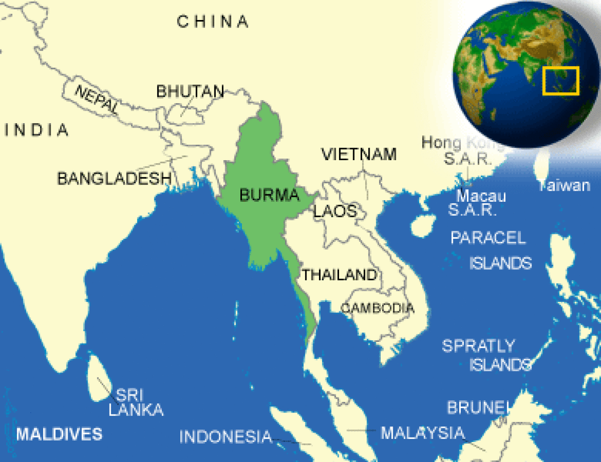
Where is Burma located?
What countries border Burma?
Burma Weather
What is the current weather in Burma?
Burma Facts and Culture
What is Burma famous for?
- Cultural Attributes: Given the Buddhist teaching of non-violence toward all creatures, animals, even insects as well as humans, the Burmese people are... More
- Family: In Myanmar, there are two words for family: ein daung zu (the household group) and mi thaa zu (the mother... More
- Personal Apperance: Most Burmese men wear a traditional sarong referred to as a “longyi” with a western-style shirt. Women wear a similar... More
- Recreation: The tradition of kickboxing (myanma let-hwei) dates back hundreds of years. Special competitions are held during paya pwe (local pagoda... More
- Diet: Burmese cuisine is not well known internationally. It includes influences from China, India, and Thailand. Rice is the Burmese staple,... More
- Food and Recipes: Ngapi, a strong-flavored pickled fish, is eaten at most meals. More
- Visiting: When introduced to Burmese people, always refer to them by their full name, regardless of whether it is two or... More
- Dating: Burmese Buddhist weddings are strictly civil or non-religious ceremonies. There are two phases to a wedding - the nuptial and... More
Burma Facts
What is the capital of Burma?
| Capital | Rangoon (aka Yangon, continues to be recognized as the primary Burmese capital by the US Government); Nay Pyi Taw is the administrative capital |
| Government Type | military regime |
| Currency | kyats (MMK) |
| Total Area |
261,227 Square Miles 676,578 Square Kilometers |
| Location | Southeastern Asia, bordering the Andaman Sea and the Bay of Bengal, between Bangladesh and Thailand |
| Language | Burmese |
| GDP - real growth rate | 8.1% |
| GDP - per capita (PPP) | $6,000.00 (USD) |
Burma Demographics
What is the population of Burma?
| Ethnic Groups | Burman 68%, Shan 9%, Karen 7%, Rakhine 4%, Chinese 3%, Indian 2%, Mon 2%, other 5% |
| Languages | Burma is a nation of many races - some 135 ethnic groups, with their own languages and dialects, make up its population of nearly 45 million. It is impossible to mention more than a few of the races, for Burma is an anthropologist's paradise. The Burmese people call their own language Bamar or Myanmar and it is the main language spoken throughout the country. About 70 percent of the people of Burma speak one or other of the Burma Group of languages while the percentage of those speaking Burmese is estimated at ninety. Despite the diversity and geographic separation, the national groups share with each other a wide variety of social customs and cultures. The Burmese language vocabulary contains a large number of Pali and Sanskrit words. The earliest Burmese writing was the Myazedi Stone Inscription. which is a four-sided stone inscription constructed in 1113 A.D. during the Pagan Period. The inscription is written in Myanmar, Pyu, Mon, and Pali and was discovered in 1887. |
| Nationality Noun | Burmese (singular and plural) |
| Population | 56,590,071 |
| Population - note | Note: estimates for this country take into account the effects of excess mortality due to AIDS; this can result in lower life expectancy, higher infant mortality, higher death rates, lower population growth rates, and changes in the distribution of the population by age and sex than would otherwise be expected. |
| Population Growth Rate | 1.05% |
| Population in Major Urban Areas | RANGOON (capital) 4.457 million; Mandalay 1.063 million; Nay Pyi Taw 1.06 million |
| Urban Population | 32.600000 |
Burma Government
What type of government does Burma have?
| Executive Branch |
chief of state: Prime Minister, State Administration Council Chair, Sr. Gen. MIN AUNG HLAING (since 1 August 2021); note - the military took over the government on 1 February 2021 and declared a state of emergency head of government: Prime Minister, State Administration Council Chair, Sr. Gen. MIN AUNG HLAING (since 1 August 2021) cabinet: Cabinet appointments shared by the president and the commander-in-chief; note - on 2 February 2021, the military leadership replaced the Cabinet with the State Administrative Council (SAC), which is the official name of the military government in Burma elections/appointments: prior to the military takeover in 2021, president was indirectly elected by simple majority vote by the full Assembly of the Union from among 3 vice-presidential candidates nominated by the Presidential Electoral College (consists of members of the lower and upper houses and military members); the other 2 candidates become vice presidents (president elected for a 5-year term); general election last held on 8 November 2020; the military junta has pledged to hold new general elections but has repeatedly announced delays election results: 2020: the National League for Democracy (NLD) won 396 seats across both houses, well above the 322 required for a parliamentary majority, which would have ensured that its preferred candidates would be elected president and second vice president in the Presidential Electoral College; however, on 1 February 2021 the military claimed the results of the election were illegitimate and launched a coup d'état that deposed State Counsellor AUNG SAN SUU KYI and President WIN MYINT of the NLD, causing military-affiliated Vice President MYINT SWE (USDP) to become Acting President; MYINT SWE subsequently handed power to coup leader MIN AUNG HLAING; WIN MYINT and other key leaders of the ruling NLD party were placed under arrest following the military takeover 2018: WIN MYINT elected president in an indirect by-election held on 28 March 2018 after the resignation of HTIN KYAW; Assembly of the Union vote for president - WIN MYINT (NLD) 403, MYINT SWE (USDP) 211, HENRY VAN THIO (NLD) 18, 4 votes canceled (636 votes cast) state counsellor: State Counselor AUNG SAN SUU KYI (since 6 April 2016); note - under arrest since 1 February 2021; formerly served as Minister of Foreign Affairs and Minister for the Office of the President note: a parliamentary bill creating the position of "state counsellor" was signed into law by former President HTIN KYAW on 6 April 2016; a state counsellor serves the equivalent term of the president and is similar to a prime minister in that the holder acts as a link between the parliament and the executive branch |
| Suffrage | 18 years of age; universal |
| Citizenship |
citizenship by birth: no citizenship by descent only: both parents must be citizens of Burma dual citizenship recognized: no residency requirement for naturalization: none note: an applicant for naturalization must be the child or spouse of a citizen |
| National Holiday | Independence Day, 4 January (1948); Union Day, 12 February (1947) |
| Constitution |
history: previous 1947, 1974 (suspended until 2008); latest drafted 9 April 2008, approved by referendum 29 May 2008 amendments: proposals require at least 20% approval by the Assembly of the Union membership; passage of amendments to sections of the constitution on basic principles, government structure, branches of government, state emergencies, and amendment procedures requires 75% approval by the Assembly and approval in a referendum by absolute majority of registered voters; passage of amendments to other sections requires only 75% Assembly approval; military granted 25% of parliamentary seats by default; amended 2015 |
| Independence | 4 January 1948 (from the UK) |
Burma Video
YouTube: Jacob + Katie Schwarz Burma (Myanmar)
CountryReports YouTube Channel:
Join CountryReports YouTube Channel (Click Here)Burma Geography
What environmental issues does Burma have?
| Overview |
Burma (also known as Myanmar), with an area of 262,000 square miles, is the largest country in mainland Southeast Asia. Rangoon (also called Yangon), the capital (population of about 5.5 million), is Burma’s largest city. Mandalay (population 700,000) is second. Burma’s population is about 49 million. Rangoon is Burma’s most important port for both domestic and foreign trade. Located on the Yangon River, 30 miles north of the Gulf of Martaban, it serves not only oceangoing freighters and tankers but also river steamers and country craft that ply Rangoon’s major waterways. The city is built on flat lowland bounded on three sides by the Pazundaung Creek and the Yangon and Hlaing Rivers. The surrounding countryside consists of rice paddies, patches of brush, and occasional rubber plantations. |
| Climate |
Located in the Southeast Asian monsoon belt, Rangoon has a tropical climate with three distinct seasons: monsoon, cool, and hot. During the monsoon season, mid-May through mid-October, Rangoon receives most of its 100-inch plus average annual rainfall. Temperatures are moderate (75°F-90°F), but relative humidity is high. During the monsoon, dampness and mildew can cause serious damage to clothing, furniture, books, records, electrical appliances, and leather goods. In mid-November, after a brief period of warm, humid weather, the cool season begins from then until March, weather is pleasant (60°F-90°F) with lower humidity and almost no rain. Days are sunny and clear; nights are cool. In March, temperatures and humidity rise until the monsoon begins in mid-May. During the March-May hot season, the weather is hot and humid, usually rising in the day to over 100°F. As at most tropical posts, insects and snakes are numerous year-round. |
| Border Countries | Bangladesh 193 km, China 2,185 km, India 1,463 km, Laos 235 km, Thailand 1,800 km |
| Environment - Current Issues | Deforestation; industrial pollution of air, soil, and water; inadequate sanitation and water treatment contribute to disease |
| Environment - International Agreements |
Party To: Biodiversity, Climate Change, Climate Change-Kyoto Protocol, Desertification, Endangered Species, Law of the Sea, Ozone Layer Protection, Ship Pollution, Tropical Timber 83, Tropical Timber 94 signed, but not ratified: none of the selected agreements |
| Terrain | Central lowlands ringed by steep, rugged highlands |
<b>Burma Economy</b>
How big is the Burma economy?
| Economic Overview |
Since Burma began the transition to a civilian-led government in 2011, the country initiated economic reforms aimed at attracting foreign investment and reintegrating into the global economy. Burma established a managed float of the Burmese kyat in 2012, granted the Central Bank operational independence in July 2013, enacted a new anti-corruption law in September 2013, and granted licenses to 13 foreign banks in 2014-16. State Counsellor AUNG SAN SUU KYI and the ruling National League for Democracy, who took power in March 2016, have sought to improve Burma’s investment climate following the US sanctions lift in October 2016 and reinstatement of Generalized System of Preferences trade benefits in November 2016. In October 2016, Burma passed a foreign investment law that consolidates investment regulations and eases rules on foreign ownership of businesses. Burma’s economic growth rate recovered from a low growth of under 6% in 2011 but has been volatile between 6% and 7.2% during the past few years. Burma’s abundant natural resources and young labor force have the potential to attract foreign investment in the energy, garment, information technology, and food and beverage sectors. The government is focusing on accelerating agricultural productivity and land reforms, modernizing and opening the financial sector, and developing transportation and electricity infrastructure. The government has also taken steps to improve transparency in the mining and oil sectors through the publication of reports under the Extractive Industries Transparency Initiative (EITI) in 2016 and 2018. Despite these improvements, living standards have not improved for the majority of the people residing in rural areas. Burma remains one of the poorest countries in Asia – approximately 26% of the country’s 51 million people live in poverty. The isolationist policies and economic mismanagement of previous governments have left Burma with poor infrastructure, endemic corruption, underdeveloped human resources, and inadequate access to capital, which will require a major commitment to reverse. The Burmese Government has been slow to address impediments to economic development such as unclear land rights, a restrictive trade licensing system, an opaque revenue collection system, and an antiquated banking system. |
| Industries | Agricultural processing; wood and wood products; copper, tin, tungsten, iron; cement, construction materials; pharmaceuticals; fertilizer; oil and natural gas; garments; jade and gems |
| Currency Name and Code | kyats (MMK) |
| Export Partners | China 37.7%, Thailand 25.6%, India 7.7%, Japan 6.2% |
| Import Partners | China 42.2%, Thailand 18.5%, Singapore 11%, Japan 4.8% |
Burma News and Current Events
What current events are happening in Burma?
Source: Google News
Burma Travel Information
What makes Burma a unique country to travel to?
Country Description
Burma (Myanmar) is a developing agrarian country emerging from decades of rule by an authoritarian military regime. Elections in November 2010 led to a peaceful transition to a civilian government headed by President Thein Sein. Under President Thein Sein, the Government of Burma has initiated a series of political and economic reforms which have resulted in a substantial opening of the long-isolated country. These reforms have included the release of many political prisoners, preliminary peace agreements with some armed ethnic groups, greater freedom of the press, and parliamentary by-elections in 2012 in which pro-democracy leader Aung San Suu Kyi and her opposition party won a landslide victory and seats in parliament.After a long period of isolation, Burma has started to encourage tourism. As a foreigner, you can expect to pay more than locals do for accommodations, domestic airfares, and entry to tourist sites. Tourist facilities in Rangoon, Bagan, Ngapali Beach, Inle Lake, and Mandalay are superior to tourist facilities in other parts of the country, where they are limited or nonexistent.
Crime
Crime rates in Burma, especially toward foreigners, are lower than those of many other countries in the region. Nevertheless, the crime rate has been increasing. Violent crime against foreigners is rare.Don’t buy counterfeit and pirated goods, even if they are widely available. Not only are the bootlegs illegal in the United States, but if you purchase them, you may also be breaking local law.
Criminal Penalties
While you are traveling in Burma, you are subject to its laws, even if you are a U.S. citizen. Foreign laws and legal systems can be vastly different than our own. It is illegal to take pictures of Burmese officials and of certain buildings, such as military installations and government buildings. There are also some things that might be legal in Burma, but still illegal in the United States. You can be prosecuted under U.S. law if you buy pirated goods. Engaging in sexual conduct with children or using or disseminating child pornography in a foreign country is a crime prosecutable in the United States.While in Burma, you should carry your U.S. passport or a photocopy of passport data and visa pages at all times so that if you are questioned by Burmese officials, you will have proof of your U.S. citizenship readily available. It is important to remember, however, that your U.S. passport won’t help you avoid arrest or prosecution for violating local laws.
Some foreigners have been denied even minimal rights in criminal proceedings in Burma, especially when suspected of engaging in political activity of any type. This includes, but is not limited to, denial of access to an attorney, denial of access to court records, and denial of family and consular visits. Although the current civilian government has repealed some of the laws that prohibited people from exercising many of the rights that U.S. citizens enjoy in the United States – including the freedoms of assembly and speech – there are still many laws on the books that criminalize things that are not illegal in the United States. For example, Burmese law forbids Burmese citizens from possessing dual nationality.
Under the Burmese Motor Vehicle Act of 1964, driving while intoxicated is punishable by either six months in jail, a 500 kyat (equivalent to USD 50 cents) fine, or both.
Based on the Vienna Convention on Consular Relations and customary international law, if you are arrested in Burma, you have the option to request that the police, prison officials, or other authorities alert the U.S. Embassy of your arrest, and to have communications from you forwarded to the U.S. Embassy.
Languages
Burma is a nation of many races - some 135 ethnic groups, with their own languages and dialects, make up its population of nearly 45 million. It is impossible to mention more than a few of the races, for Burma is an anthropologist's paradise. The Burmese people call their own language Bamar or Myanmar and it is the main language spoken throughout the country. About 70 percent of the people of Burma speak one or other of the Burma Group of languages while the percentage of those speaking Burmese is estimated at ninety. Despite the diversity and geographic separation, the national groups share with each other a wide variety of social customs and cultures. The Burmese language vocabulary contains a large number of Pali and Sanskrit words. The earliest Burmese writing was the Myazedi Stone Inscription. which is a four-sided stone inscription constructed in 1113 A.D. during the Pagan Period. The inscription is written in Myanmar, Pyu, Mon, and Pali and was discovered in 1887.
Medical Facilities and Health Information
We highly recommend that you share your travel plans with your doctor so that you can best prepare for the endemic health-related challenges that confront travelers in Burma. Most medical facilities in Burma are inadequate for even routine medical care. There are very few medical personnel in Burma who are trained to U.S. standards. You should also know that, in an emergency, you would likely need to be medically evacuated to a hospital outside Burma. Medical evacuation from Burma is expensive and is transacted in cash. We strongly urge all travelers to secure medical evacuation insurance before coming to Burma. Most pharmaceuticals on sale in Burma have been smuggled into the country, and many are counterfeit or adulterated. Travelers should consider Burmese pharmaceuticals generally unsafe to use and should accordingly bring adequate supplies of their medications for the duration of their stay in Burma. All travelers are advised to bring a complete and detailed list of regularly used medicine, and dosages, in case of an emergency. HIV/AIDS is widespread among high-risk populations, such as prostitutes and illegal drug users. Malaria, dengue fever, tuberculosis, hepatitis, and other infectious diseases are endemic in many parts of the country.In early 2006 throughout 2007, and again in early 2010, brief avian influenza outbreaks resulted in the death of domestic poultry and some wild birds. In December 2007, the World Health Organization and Burmese Ministry of Health confirmed Burma’s first case of human infection with the H5N1 avian influenza virus. If you travel to Burma and other South Asian countries affected by avian influenza, we caution you to avoid poultry farms, contact with animals in live food markets, and any other surfaces that appear to be contaminated with feces from poultry or other animals. There were no reported human cases of H5N1 in Burma during the 2010 outbreaks.
Safety and Security
Over a period of years, Burma has experienced sporadic bombing attacks, primarily targeting government buildings and vehicles. In January 2013, improvised explosive devices (IED) were used in three attacks in Kachin State. In June 2011, bombings targeted a variety of local facilities, including government offices, public restrooms, a public phone booth, markets, and in one instance a train traveling from Mandalay to Rangoon. In April 2010, a series of explosions among a crowd of revelers at a Water Festival celebration in Rangoon killed at least ten people and wounded as many as 170. There is no indication that these attacks targeted U.S. citizens or U.S. interests.Conflicts between the government and various ethnic minority groups continue in a number of border regions in Burma, and anti-personnel landmines in some border areas pose an additional danger. Occasional fighting between government forces and various rebel groups has occurred in Chin State and Sagaing Division near India and along Burma's Kachin, Shan, Mon, Kayah, and Karen States' borders with China and Thailand. From time to time, the governments of Burma and Thailand have closed the border between the two nations on short notice. Recent military actions in Kachin State by the Kachin Independence Army (KIA) and the Burmese Army have endangered the lives of civilians.
Sectarian violence in Rakhine State in June and October 2012 reportedly left many people dead and displaced thousands of others. The violence also resulted in demonstrations in Rangoon and elsewhere.
In light of these incidents, you should exercise caution in public places at all times. Be alert to your surroundings and the presence of unattended packages or bags or suspicious objects/activity in public areas. Furthermore, avoid crowded public places, such as large public gatherings, demonstrations, and any areas cordoned off by security forces; problems can develop quickly. Even demonstrations that are meant to be peaceful can become violent and unpredictable. While in Burma, you should closely follow media reports and public information about the security situation in Burma. Given the Government of Burma's restrictions on travel by U.S. diplomats, U.S. Government assistance to U.S. citizens affected by incidents in remote areas of Burma may be difficult.
Traffic Safety and Road Conditions
While in a foreign country, you may encounter road conditions that differ significantly from those in the United States. The information below concerning Burma is provided for your general reference only, and may not be accurate in a particular location or circumstance.Rangoon's main roads are generally in poor condition. Traffic in the capital has increased rapidly, resulting in traffic congestion during morning and early evening rush hours. Some roads are in serious disrepair. Slow-moving vehicles, bicycles, animals, and heavy pedestrian traffic create numerous hazards for drivers on Rangoon's streets. If you drive in Burma, you must remain extremely alert to avoid hitting pedestrians.
Most roads outside of Rangoon consist of one to two lanes and are potholed, often unpaved, and unlit at night. Many of the truck drivers traveling from China to Rangoon are believed to drive under the influence of methamphetamines and other stimulants. Drunken and/or drugged drivers are also common on the roads during the four-day Buddhist water festival in mid-April. Driving at night is particularly dangerous. Few streets are adequately lit. Most Burmese drivers do not turn on their headlights until the sky is completely dark; many do not use headlights at all. Many bicyclists use no lights or reflectors.
Vehicular traffic moves on the right side, as in the United States; however, a majority of vehicles have the steering wheel positioned on the right. The “right of way” concept is generally respected, but military convoys and motorcades always have precedence. Most vehicle accidents are settled between the parties on site, with the party at fault paying the damages. In the event of an accident with a pedestrian, the driver is always considered to be at fault and subject to fines or arrest, regardless of the circumstances. Accidents that require an investigation are concluded quickly and rarely result in criminal prosecution. There is no roadside assistance, and ambulances are not available. Vehicles generally do not have seat belts. Child car seats are also not available.
World Regions
All Countries
Afghanistan
Akrotiri
Albania
Algeria
American Samoa
Andorra
Angola
Anguilla
Antarctica
Antigua and Barbuda
Argentina
Armenia
Aruba
Australia
Austria
Azerbaijan
Bahamas
Bahrain
Bangladesh
Barbados
Belarus
Belgium
Belize
Benin
Bermuda
Bhutan
Bolivia
Bosnia and Herzegovina
Botswana
Brazil
British Indian Ocean Territory
British Virgin Islands
Brunei
Bulgaria
Burkina Faso
Burma
Burundi
Cabo Verde
Cambodia
Cameroon
Canada
Cayman Islands
Central African Republic
Chad
Chile
China
Christmas Island
Clipperton Island
Cocos (Keeling) Islands
Colombia
Comoros
Congo, Democratic Republic of the
Congo, Republic of the
Cook Islands
Coral Sea Islands
Costa Rica
Cote d’Ivoire
Croatia
Cuba
Curacao
Cyprus
Czech Republic
Denmark
Dhekelia
Djibouti
Dominica
Dominican Republic
Ecuador
Egypt
El Salvador
Equatorial Guinea
Eritrea
Estonia
Eswatini
Ethiopia
Falkland Islands
Faroe Islands
Fiji
Finland
France
French Guiana
French Polynesia
Gabon
Gambia, The
Gaza Strip
Georgia
Germany
Ghana
Gibraltar
Greece
Greenland
Grenada
Guadeloupe
Guam
Guatemala
Guernsey
Guinea
Guinea-Bissau
Guyana
Haiti
Holy See
Honduras
Hong Kong
Hungary
Iceland
India
Indonesia
Iran
Iraq
Ireland
Isle of Man
Israel
Italy
Jamaica
Jan Mayen
Japan
Jersey
Jordan
Kazakhstan
Kenya
Kiribati
Korea, North
Korea, South
Kosovo
Kuwait
Kyrgyzstan
Laos
Latvia
Lebanon
Lesotho
Liberia
Libya
Liechtenstein
Lithuania
Luxembourg
Macau
Madagascar
Malawi
Malaysia
Maldives
Mali
Malta
Marshall Islands
Martinique
Mauritania
Mauritius
Mayotte
Mexico
Micronesia
Moldova
Monaco
Mongolia
Montenegro
Montserrat
Morocco
Mozambique
Namibia
Nauru
Nepal
Netherlands
New Caledonia
New Zealand
Nicaragua
Niger
Nigeria
Niue
Norfolk Island
North Macedonia
Northern Mariana Islands
Norway
Oman
Pakistan
Palau
Panama
Papua New Guinea
Paraguay
Peru
Philippines
Pitcairn Islands
Poland
Portugal
Puerto Rico
Qatar
Reunion
Romania
Russia
Rwanda
Saint Helena, Ascension, and Tristan da Cunha
Saint Kitts and Nevis
Saint Lucia
Saint Pierre and Miquelon
Saint Vincent and the Grenadines
Samoa
San Marino
Sao Tome and Principe
Saudi Arabia
Senegal
Serbia
Seychelles
Sierra Leone
Singapore
Slovakia
Slovenia
Solomon Islands
Somalia
South Africa
Spain
Sri Lanka
Sudan
Sudan, South
Suriname
Svalbard
Sweden
Switzerland
Syria
Taiwan
Tajikistan
Tanzania
Thailand
Timor-Leste
Togo
Tokelau
Tonga
Trinidad and Tobago
Tunisia
Turkey
Turkmenistan
Turks and Caicos Islands
Tuvalu
Uganda
Ukraine
United Arab Emirates
United Kingdom
United States (US)
Uruguay
Uzbekistan
Vanuatu
Venezuela
Vietnam
Virgin Islands
Wake Island
Wallis and Futuna
West Bank
Western Sahara
World
Yemen
Zambia
Zimbabwe